Water Is Life
When nature doesn’t have enough water, it’s only a matter of time before people don’t either.

Securing California's Water Future
Our state's water system is one of the most heavily engineered on the planet. California takes water from rivers, streams and aquifers and we do it with very few limits, leaving rivers to run dry, putting nature and people at risk.
If we don't fix the flows, there won't be enough water for anyone.
TNC's Water Plan for California
We identify precisely when and where nature needs water, and build the partnerships, projects and policies necessary to deliver it.
How we get there:
- Secure water for wetlands. Recover water supplies for California’s wetlands and create seasonal habitat for the migratory birds that rely on them.
- Make rivers flow again. Buy water, drive policy and catalyze partnerships to return flows to rivers.
- Rebalance water use. Work with farmers to change water use practices so communities and wildlife can thrive.
Tackling the Barriers to Healthy River Flows
TNC has identified the three main reasons that California's rivers are in trouble. At the same time, we have three strategies to change the status quo.


A Strategy for Scaling Up
To address the variety of problems plaguing flows, we are working strategically in the set of rivers shown in the map above. Within this portfolio, we dig into each river’s unique conditions to identify the right toolkit of solutions. From our deep engagement in these places, we use what we learn to identify the barriers to further action, and then we develop policy interventions and technical tools that can expand our solutions to other rivers.
-
To increase flows in smaller, coastal watersheds, we are working in the Navarro River to improve the timing of diversions. We are helping local vineyards secure winter water rights so they can store water for summer irrigation, keeping more water in the river when flows are low. We are also helping landowners make landscape changes that slow the runoff from rainstorms, allowing water to seep into the soil and recharge groundwater—which adds flow to rivers and creeks as well. Along the way, we learned it can take far too long (seven years, in one case) to permit such projects. To make more projects happen, we are providing tools to speed up applications and partnering with agencies to understand how to fast-track projects that benefit nature—a solution that will apply well beyond the Navarro.
-
In the large, highly altered rivers of the Klamath Basin, we’re employing a different approach: acquiring water rights. TNC recently acquired Miners Creek Ranch, a property located on a tributary to the Scott River that comes with senior water rights. Applying our science, we have identified when and where the stream needs more water, and we are reducing irrigation on the ranch to keep water in the stream at these times, restoring the flows that endangered coho salmon need to reproduce and thrive. Holding water rights gives us a seat at the table with water regulators, which we are using to advance rules for how much water stays instream in the watershed. Using our experience in this region, we are advocating for the state to take similar action in other unregulated rivers, to help guide water use and catalyze investments that lead to improved flows.
-
Dam removal can take too long and cost too much--even when there is agreement that it should happen. To address this, TNC is working on several fronts. For large dams, such as in Battle Creek in the Lassen foothills, we are building diverse coalitions to maintain pressure on the removal process and speed up action. And where we can, we are removing dams ourselves. For instance, on our Jack and Laura Dangermond Preserve, we are demolishing two dams that have prevented endangered Southern California steelhead from accessing suitable spawning habitat in the Jalama Creek watershed.
Healthy Rivers
In California and around the world, rivers are the lifelines of our natural and human communities. Flowing throughout our state’s deserts, redwood forests, Sierra mountains and great Central Valley, California’s rivers provide a home for thousands of freshwater species, supply drinking water to more than 30 million Californians and are a significant water source for our $40 billion agricultural economy. They were also once home to many of the largest salmon migrations on the Pacific Coast—with seasonal runs in coastal rivers and the Central Valley numbering in the hundreds of thousands—a natural phenomenon that has dwindled to a trickle.
California’s outdated approaches to water management are failing to meet the water needs of people and nature, especially when water is the most scarce during the summer. By taking huge volumes of water directly from our rivers and by storing large amounts behind dams, we’ve severely altered how much water is flowing in our rivers and when. The amount of water in our rivers naturally varies from season to season throughout the year—and species like salmon and steelhead have evolved according to this fluctuation. But human alteration has left few resources for even the best drought-adapted species. At its worst, overuse and inefficient management are drying up some rivers during the summer, leaving no water for fish or for people.

The good news is that in many cases, by being more efficient with our water use and dynamically managing when we take water from rivers, we can meet the needs of both people and river ecosystems. To overcome the challenges our rivers face, we are:
- Using our science and working with partners to, for the first time in California history, determine how much water is needed in our rivers to support wildlife, for all rivers in the state and for all months in the year. And we are using these thresholds to influence policy.
- Supporting on-the-ground river flow projects, such as community-level collaboration among water users, using techniques like water storage and changing the timing of diversions. We then proliferate these techniques statewide using a network approach.
- Buying our own water that we can choose to leave in the river for fish, or transfer to farms and wildlife refuges to create habitat for birds.
- Promoting policy reforms to accelerate the pace of implementing water management solutions and supporting legislation to increase the state’s preparedness for future droughts.


Through these approaches, we are helping bring water security to people and ensuring enough water is left in rivers at the right times so salmon, steelhead and other river species can thrive. Since 2009, we have worked with partners to restore seasonal flow patterns to four rivers that are critically important to salmon and have purchased or facilitated more than 26,000 acre-feet (more than 8.5 billion gallons) of water to be left in rivers to support wildlife. This work complements TNC’s legacy of river habitat conservation for salmon and steelhead on more than 5,000 river miles statewide.
Thriving Birds and Wetlands
California’s Central Valley used to be a 10 million-acre wilderness, dotted with more than 4 million acres of lush wetlands. These wetlands were prime habitat for tens of millions of birds that migrated along the Pacific Flyway, a highway in the sky for birds stretching from the Arctic tundra to Patagonia, the southernmost tip of South America.

Today, more than 95% of Central Valley wetlands have disappeared, lost to farmland, urban sprawl, and an overburdened water system. Only about 200,000 acres of wetlands remain, far less than is needed to support the millions of waterbirds that still arrive each year looking for a place to rest and refuel on their amazing migratory journeys.
Many species that once depended on the historic wetlands of the Central Valley are now in deep trouble. Shorebirds, of which there are over 25 species in California, are particularly imperiled. North American shorebird populations have declined by almost 40% in just the last 50 years, and the Central Valley is second only to Great Salt Lake in the numbers of shorebird it supports. Although still a stronghold for the birds, this region is at great risk due to land conversion and mismanagement, compounded by climate change-induced increases in the frequency and severity of drought. Even in very wet years, suitable habitat is often not available when birds need it.
Fortunately, the hard work we've been doing to improve management of existing wetlands and our creative use of farmlands to create additional high value habitat is beginning to pay off. Key components of our work to meet the habitat needs of migrating shorebirds include:
- Purchasing and delivering water to farmland and existing public wetlands.
- Creating “pop-up” wetlands on farmland and managed wetlands, using big data and a reverse auction market to select the highest value habitat, and scaling this approach through a network of partners.
- Building on this “pop-up” model to simultaneously replenish underground aquifers, thus benefiting farmers and others who rely on groundwater as well as the birds.


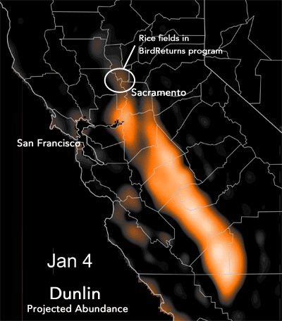
Since 2014, BirdReturns has worked with well over 200 farmers to create over 180,000 acres of high-quality, seasonal wetland habitat.
By continuing to scale these approaches, we seek to create 350,000 new acres of habitat annually by 2050 so that California’s shorebird populations, and the Pacific Flyway at large, can grow and thrive.
Sustainable Groundwater

Aquifers underground formed over millions of years. They are now one of the primary freshwater sources in California. About 85% of Californians depend on this underground water (known as groundwater) for some portion of their water supply. In a wet year in California, aquifers provide 40% of the water people use—in dry years, that number jumps to 60%. These percentages are even higher in the agricultural Central Valley and Central Coast. People pump this water out of the ground for drinking and irrigation, and native plants stretch their roots down deep to reach the water, creating wildlife habitat.
Unfortunately, in many places, people are pumping this groundwater faster than rain can replenish it. Along with droughts, the unsustainable pumping of groundwater is leading to drinking water shortages and declining water quality for disadvantaged communities. Dying crops, habitat loss, and species extinctions are also unfortunate side effects. In some areas, land has even sunk by up to 30 feet.
Fortunately, with the support of TNC, California passed the Sustainable Groundwater Management Act, which, for the first time, limits the amount of groundwater that can be pumped, in the most affected parts of the state. The Act requires that local water agencies devise plans to stabilize their groundwater pumping, and thanks to TNC’s influence, it is one of only four pieces of legislation in the world that require nature’s groundwater needs to be considered alongside people’s.
TNC is working to ensure that plans go beyond lip service and achieve actual sustainability. To do this, we’re providing feedback to the State on how well the submitted plans address the water needs of nature and the drinking water needs of disadvantaged communities. We’re also piloting solutions that simultaneously benefit wildlife, farmers, and disadvantaged communities, and making these solutions available to local water agencies that need to deliver on their sustainability plans. These solutions include:
Decreasing groundwater demand by creating markets to trade groundwater and strategies for restoring parcels of farmland to habitat where it most benefits wildlife.
Increasing groundwater supply through groundwater replenishment.

Finally, given that groundwater is a primary water source in locations outside the Central Valley as well, TNC is working to expand sustainable groundwater management policies to cover the entire state.
Our goal is to sustain 3.6 million acres of groundwater-dependent ecosystems by 2050, providing habitat for more than 1,500 species of plants and animals. Through all this work, we will enable sustainable groundwater-use that gives people a reliable and resilient water supply, while also allowing groundwater-dependent wildlife to flourish.
Resources
Make a Difference in California
Help us support sustainable water management that benefits both people and nature.
You may also like

Water Markets
Like a stock market…but for water. In times of water scarcity, water markets bring financial stability, flexibility and sustainability to agriculture and nature alike.

Protecting Salmon and Steelhead in the Navarro River
Working with partners along the Navarro River to develop solutions that preserve water for salmon and people.

BirdReturns: A Habitat Timeshare for Migratory Birds
When it comes to habitat, why buy when you can rent?