The East River: A More Resilient Watershed
New project focuses on partnerships to tackle flooding and water quality issues in Brown County.
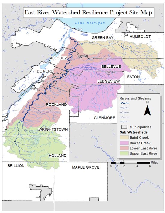
Open a map of Brown County, Wisconsin, and you’ll immediately notice the boundary lines for cities, towns and villages like Green Bay, De Pere, Allouez and Holland. You’ll see the Fox River wending its way to the bay of Green Bay, and you might even notice the smaller East River running alongside to join it as they empty into Lake Michigan. What you won’t see is lines marking the watershed that connects them all, or the flooding and water quality issues that have increasingly impacted the people who call the area home.
East River Collaborative
Remove all the artificial lines on the map, and many of us might find ourselves quite lost. For Kayla Wandsnider, The Nature Conservancy’s East River Community Resilience Fellow, removing those borders helps bring things into focus.
It’s a view that Wandsnider hopes to foster in others as she works with community partners for the East River Collaborative (ERC). The goal of the ongoing project is ambitious but crucial: Bring together the communities within the watershed to work collaboratively to tackle flooding and water quality problems.

The previous fellow, Blake Neumann, met with municipal boards and other potential partners as an early step to better understand the information gaps in watershed knowledge and to provide suggestions for how to address them. The first phase of the project guided the communities in a self-assessment of their resiliency preparedness. All of this is the foundation of the Resilient East River Framework—an outline for community-based watershed priorities that municipal planners and decision makers can use to guide the creation of a comprehensive strategic plan for the watershed.
“Viewing our communities from the watershed level is a great way to really understand how we’re all connected and the kind of collaborative work that’s required to tackle the challenges we’re now facing,” Wandsnider explains. “Every drop of water that falls within a watershed will make its way, either over land or via tributary, into the East River and eventually into Lake Michigan.”
Water that falls on the ground as far out as Holland, some 30 miles away, will end up flowing into a lake that provides drinking water to some 10 million people. That drop of water highlights the importance of a strong, collaborative network working together to solve their interconnected issues.

TNC’s East River Community Resilience Fellow Kayla Wandsnider works with ERC partners to bring communities in the watershed together to work collaboratively on flooding and water quality problems.
Get more stories like this in your inbox!
Sign up for our monthly Nature News and stay up to date with TNC's work in Wisconsin.
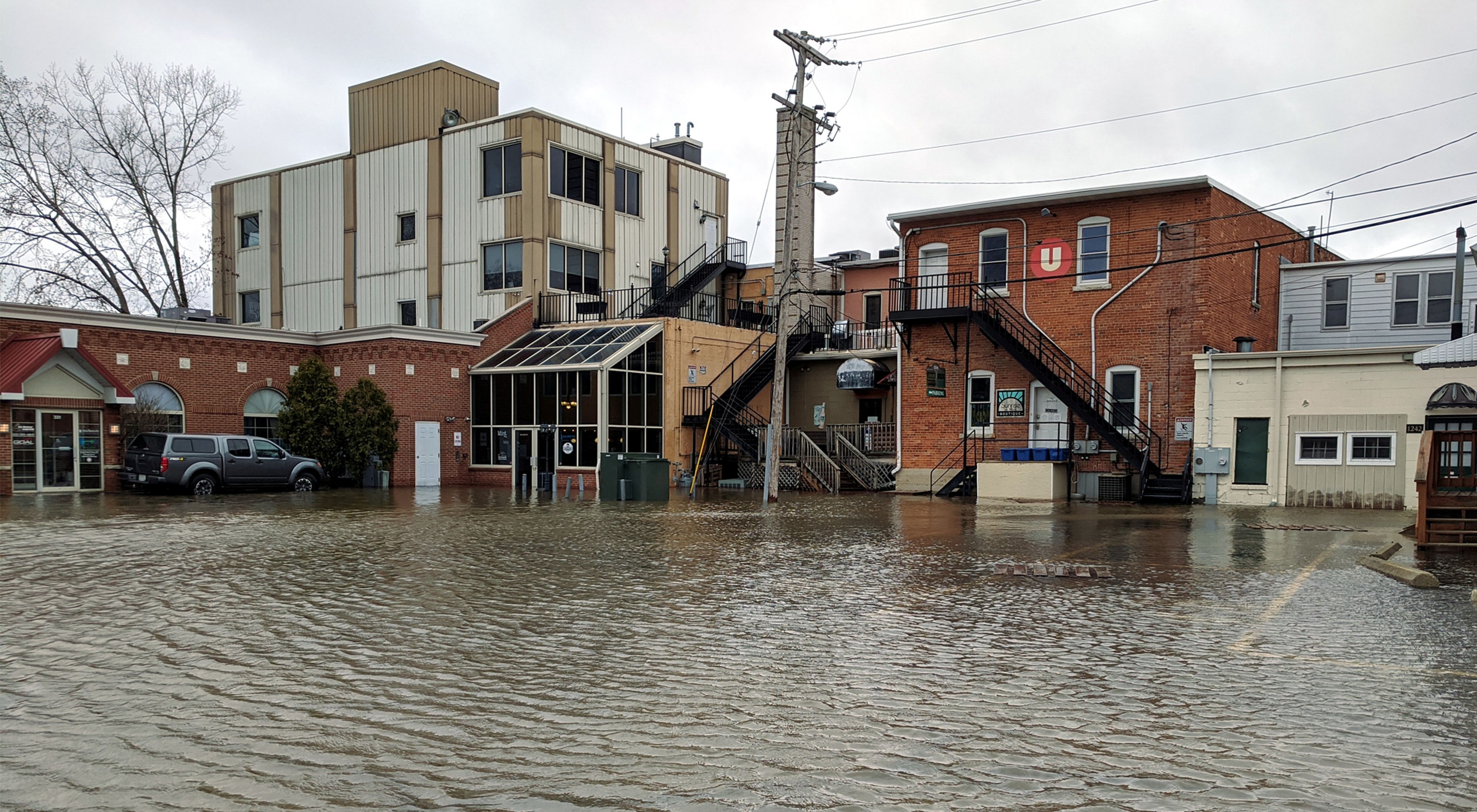
Municipal officials, farmers, local organizers and private citizens are contributing their unique expertise to inform a plan to improve water quality, protect fish habitat, sustain public access, and mitigate the impacts of flooding in the watershed that have already forced people out of their homes and caused millions of dollars of damage.
The Nature Conservancy (TNC) has partnered with Wisconsin Sea Grant and NEW Water (the brand of the Green Bay Metropolitan Sewerage District) on the project, which also includes a major flood modeling effort led by University of Wisconsin-Madison Prof. Chin Wu. It is being undertaken with grant funding from Wisconsin Coastal Management and Fund for Lake Michigan. Previous work by TNC and partners created a restoration plan for the river corridor itself, which is helping inform this new, watershed-wide effort. The ambitious project involves Brown County, small parts of Calumet and Manitowoc counties, the cities of Green Bay and De Pere, the villages of Allouez and Bellevue, and the towns of Ledgeview, Rockland, and Wrightstown.
“Working beyond borders can be challenging for local governments,” says Julia Noordyk, University of Wisconsin Sea Grant’s water quality and coastal communities outreach specialist. “So the partnership between NEW Water, The Nature Conservancy, and Sea Grant is really to help provide the coordinating capacity to bring together those communities that are affected by flooding and water quality issues and help them move forward collaboratively.”

Increased Rainfall Adds Flooding and Water Quality Problems
Wisconsin has seen increased annual rainfall over the course of the last century, including greater frequency of extreme rainfall events and warmer average winter temperatures. Combined with population growth, ongoing development, higher lake levels, and the impacts of agricultural practices farther up the watershed, more frequent and severe flooding events have followed. The costs of the damage have run well into the millions in terms of economic fallout, while hundreds of people’s homes have been impacted and even condemned.
Those same elements factor into worsening water quality in the watershed. Nutrient runoff and sediment loss from tilled farm fields and urban development flows into the river and then empties into the bay. In fact, the East River watershed contributes the highest load of pollution to the bay, leading to poor water quality and clarity, as well as toxic blue-green algae blooms.
As the climate continues to warm, more communities are putting greater emphasis on becoming resilient in the face of these changes and the challenges they bring. Already, farmers across Wisconsin have begun to adopt and spread the word about conservation practices that make them essential partners in this effort. Low- and no-till farming, the use of cover crops, and other techniques have proven to be beneficial to both farmers’ bottom lines and the environmental health of their communities.
Nature has an important role to play, too. Wetlands are one kind of nature-based solution, providing a wide range of ecosystem benefits, including flood mitigation, water quality and habitat protection. That’s where municipalities come into play. By creating clear, consistent standards for permitting and development, communities can work together to protect places that, in turn, protect all of us.

An example of this important work can be found in TNC’s collaboration with the Green Bay, Allouez, and Ledgeview communities to use native plantings within the floodplain where 500- and 100-year rainfall events are most likely to occur. These relatively small projects have the potential for big impacts, increasing rainfall infiltration, improving water quality, and boosting wildlife habitat. The work can also help with streambank stabilization, which prevents erosion that is a contributing factor to high sediment loads in the river and Lake Michigan itself.
“We’ve added new development in areas that have always seen flooding,” Wandsnider adds. “We’ve been draining wetlands and adding more impervious surfaces to floodplains, like streets and parking lots, which increases the risk of flooding downstream. Rainwater isn’t able to soak into a road so, instead, it rushes off into the river. That’s why we see high water more often and in ways that increase the costs to people and municipalities.”
By convening several public workshops and town hall meetings, Wandsnider and project partners plan to help the public better understand what the project is all about and to gather feedback that will inform the planning process. The hope is to inspire the spirit of stewardship in everyone, bringing people together, across boundaries, to make their communities more resilient to a changing climate.


