Four Wild Trails
Explore some of The Nature Conservancy's best hiking adventures.
June/July 2015
This season, explore some of The Nature Conservancy's best hiking adventures.
Bird Loop Trail
Waikamoi Preserve, Hawaii
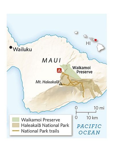
Hike the 1.25 mile Bird Loop Trail through Waikamoi Preserve, and you’ll experience one of the most pristine forests left in all of Hawai‘i. Waikamoi sits on the northeast slope of Maui’s highest mountain, the dormant Haleakala Volcano. Its peak stands 10,023 feet above sea level, and its slopes stretch from the island’s famous beaches to the mountain’s dry moonscape summit. The cloud belt in between harbors a lush, layered forest that serves as a stronghold for many of the state’s native plants and animals. An astonishing 90 percent of the species in Waikamoi are endemic, including 63 rare plants and seven endangered birds, some of which exist only on the slopes of Haleakala.
“That high rate of endemic species makes this a very special place in the world,” says Mark White, The Nature Conservancy’s Maui program director.
The trail begins in the adjacent Haleakala National Park and drops into the preserve, winding through gulches in the upper reaches of the cloud forest, where lavender-flowered Lobelia grayana sprouts from the floor. The forest canopy—dominated by the native ‘ohi‘a tree and an under-story rich with moss and ferns—is a bird-watcher’s dream and a prime place to spot the ‘amakihi and scarlet ‘i‘iwi. The preserve is only open to the public for one guided trip per week, so get your name on the list early.

Aravaipa Canyon
Aravaipa Canyon Preserve, Arizona
Aravaipa is one of the most remote places in Arizona, and one of a few preserves in the state where hikers don’t follow blazed trails. Visitors here explore a 10-mile-long chasm with 1,000-foot-high walls rising from the creek bed, all of which are sandwiched inside a massive complex of designated wilderness area. The Nature Conservancy’s 9,000-acre Aravaipa Canyon Preserve is split into two tracts, including the western mouth of the canyon.
“In the middle is this rare, wet oasis,” says Mark Haberstich, the preserve’s manager. “It’s a miniature version of the Grand Canyon.”
Hikers follow the washed-out creek bed through the canyon, sloshing through the shallow creek and stopping to cool off in the 3-foot-deep pools that form behind fallen trees. They can also trek into the smaller canyons carved by tributary creeks. Terrain can become more challenging as you explore deeper along the side creeks.
Most people enter through the west end of the canyon, 50 miles north of Tucson. A five-mile out-and-back hike will give you a sense of the canyon, but consider a multi-day traverse of the entire gorge. A visitor’s pass from the Bureau of Land Management is required to enter the wilderness area, but it’s worth the paperwork to see the Aravaipa shift from a desert landscape with saguaro cactus to a more lush forest with natural gardens of wildflowers and bushy cottonwood trees lining the riverbeds.
Roanoke Trail
Nags Head Preserve, North Carolina
This tranquil sea-level hike traverses an extremely diverse range of coastal settings. Here, forested dunes covered with oak and beech trees transition to swamps and eventually a rugged shoreline—all in a couple of square miles. It can feel like a summery walk on most days of the year, but catch Nags Head Woods on a foggy morning and the swamps and historic sites take on a eerie and pensive tone.
Nags Head Woods Preserve protects one of the largest intact maritime forests on the Eastern Seaboard and provides a host of ecological services, from storm buffering to nesting opportunities for migrating birds. The value of this landscape lies in its diversity. “We’re not just focusing on species-specific conservation here,” says Aaron McCall, the Conservancy’s Northeast regional steward. “We’re looking at protecting the system as a whole. That’s what’s endangered, the maritime forest itself.”
The half-mile-long Discovery Trail meanders by open freshwater ponds and forested wet-lands filled with black gum trees. Then the Roanoke Trail takes you through a towering forest—with two 400-year-old live oaks—down to the banks of the Roanoke Sound, where you catch a view of Roanoke Island. Along the way, you’ll also pass historic homes and a cemetery that dates back to the 1870s.
Peaked Mountain trail
Green Hills Preserve, New Hampshire
Stand on Peaked Mountain and the entire Presidential Range, a 19-mile-long ridge that contains New England’s tallest mountains, unfolds in front of you. But considering how short the trip to the top of Peaked Mountain is, you’re basically getting a high-alpine experience at relatively low elevations. This is one of New Hampshire’s iconic views, and all you have to do to bag it is hike the moderate trail through Green Hills Preserve, the Conservancy’s 5,500- acre property.
Green Hills protects a series of 1,700- to 2,300-foot summits with distinctive rocky ridges and peaks covered in red pine. The views from these open-bedrock mountains are outstanding, particularly in winter, when the preserve turns into a snow-shoeing destination, and the distant ridges are capped in snow.
“When you’re looking at the Presidential Range, with its peaks all above treeline and covered in snow, you feel like
you’re in New Hampshire’s version of the Himalayas,” says Jeff Lougee, the Conservancy’s director of steward-ship and ecological management in the state.
To get there, just follow the Peaked Mountain Trail for 2.1 miles as it climbs 1,000 feet over powder-covered slabs of granite. The hike up Peaked Mountain is just the beginning of the adventure. Green Hills has more than 11 miles of maintained trails and many paths that connect up with adjacent public trails.


