A Volunteer’s Account: 25 Years of Wet-Dry Mapping the San Pedro River
As we gear up for the 26th year of wet-dry mapping the San Pedro, hear from dedicated TNC volunteer Ralph Waldt on what makes this effort so special.
Wet-dry mapping is a valuable tool for Arizona’s conservation work, providing data on how drought affects Arizona’s water flow and habitats.
For 25 years, hundreds of volunteers have traversed 300 miles along the San Pedro River and its key tributaries, from Mexico to Arizona, mapping where the water is and isn’t. Ralph Waldt is one such volunteer. In his own words, Ralph explains below how meaningful wet-dry mapping is to him personally.
For the past 20 years, I have participated in a coordinated volunteer project aimed at monitoring the presence of water along the length of the San Pedro River in southeastern Arizona. Organized by The Nature Conservancy, this project provides data to scientists, land managers and others on the health of the river system during the hottest and driest month of the year. The data is collected the old-fashioned way—gathered by teams who experience the river in the most intimate manner possible, by walking and wading. Every June, I collect a portion of this data along a rare, perennially flowing reach located in the river’s middle valley, often accompanied by friends and neighbors, including two this year.
We began walking around 5:30 a.m., along a waterless stretch of the riverbed. Almost immediately, we discovered fresh tracks of an adult black bear and a cougar. One and a half miles in, the magic of water appeared and flowed steadily. Because of dense brush, we waded—an easier way to travel as long as one can avoid hidden lenses of quicksand. More mammal signs and tracks appeared; deer, javelina, coyote, bobcat, raccoon, coati, skunks, cottontail rabbits, mice and rock squirrels. Familiar bird songs spilled from the forest; summer tanagers and kingbirds, ash-throated flycatchers and song sparrows and more.
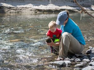
Wading this desert river in the heat of June is magical. The cottonwood-willow forest stands tall and green, casting shade enabled by millions of fluttering leaves. Eight-foot-tall burr reed (genus Scirpus) plants crowd the riverbanks. Aquatic patches of speedwell (genus Veronica) glitter with blue-purple blossoms. Tall willows form vivid green arches. Many butterflies, bees and wasps drink from water’s edge, and scores of lowland leopard frogs leap at one’s every step. Below the surface, schools of long-finned dace are darting like shafts of animated light through the clear water. The continued presence of native frogs and fish are strong, positive indicators of the health of this aquatic ecosystem.
We waded for a couple of miles until the waterway started to broaden and I suspected a beaver dam was ahead. Before long, we could see the beaver pond clearly, then the dam, plugging the river with a meter-tall, thirty-foot span of branches, twigs, tree limbs, rocks and mud. I was elated to see that this reach of the river had beaver activity. The ecological and hydrologic benefits of beavers to this river are legion. I devoted an essay to this important topic in my book, The Life of the San Pedro River.
My companions and I slithered down the steep riverbank to begin the final stretch. Suddenly one of my friends pulled me out of harm’s way. A 3-foot western diamondback rattlesnake, coiled too close for comfort, erupted in a frenzy of rattling. The forward third of the reptile’s body was off the ground in an s-curve as the snake’s glistening black tongue waved slowly, curled backwards over its snout, ready to strike. My fresh shoe print was 14 inches away, and had I not been yanked so suddenly by my alert friend, this snake would have probably tagged me. In 20 years, and hundreds of diamondback encounters, I have never come so close to one. This experience underscores a crucial rule—you should watch every footstep during the warmer months in southern Arizona! Sometimes, that is easier said than done.
The Nature Conservancy is a global conservation organization dedicated to conserving the lands and waters on which all life depends. Guided by science, we create innovative, on-the-ground solutions to our world’s toughest challenges so that nature and people can thrive together. We are tackling climate change, conserving lands, waters and oceans at an unprecedented scale, providing food and water sustainably and helping make cities more sustainable. The Nature Conservancy is working to make a lasting difference around the world in 81 countries and territories (40 by direct conservation impact and 41 through partners) through a collaborative approach that engages local communities, governments, the private sector, and other partners. To learn more, visit nature.org or follow @nature_press on X.


