Hours of visitation: Dawn to dusk, year round.
Guidelines: To help ensure that this special place can be enjoyed for future generations, please leave no trace and carry out what you carry in. Camping, littering, hunting, fires, or removal or destruction of plants or animals are prohibited. See our full preserve visitation guidelines for more information.
What to See: Between Route 4 and an abandoned shale pit, the entrance passes over the old Champlain Canal, which was opened in 1822 and was abandoned when the present canal was opened in 1917. The old canal is gradually filling with vegetation. To view what is left of one of the old canal’s locks, go north about 0.7 miles from the entrance and look on the right-hand side of the road for the old granite blocks which lined the locks.
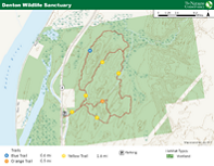
There are forests, swamps, open thickets, and grassy barrens at Denton Sanctuary. There are some notable groves of white pine and red maple in the forested area. In open areas along the yellow trail, you will find pitch pine and scrub oaks—the same species found in the Albany Pine Bush and on Cape Cod. The plant community is also evidence of past fire at the site. Waterfowl are common in the wetlands, and deer, beaver, mink and partridge are numerous throughout the preserve.
This 350-acre preserve is located in Greenwich, Washington County, New York.


